
7.7-Magnitude Earthquake Strikes Eastern Indonesia, Triggering Tsunami Panic
Two dead and buildings damaged as a shallow Flores Sea quake sends thousands to higher ground; the tsunami warning was lifted after waves peaked at 0.94 metres
Part of theASEAN Markets Center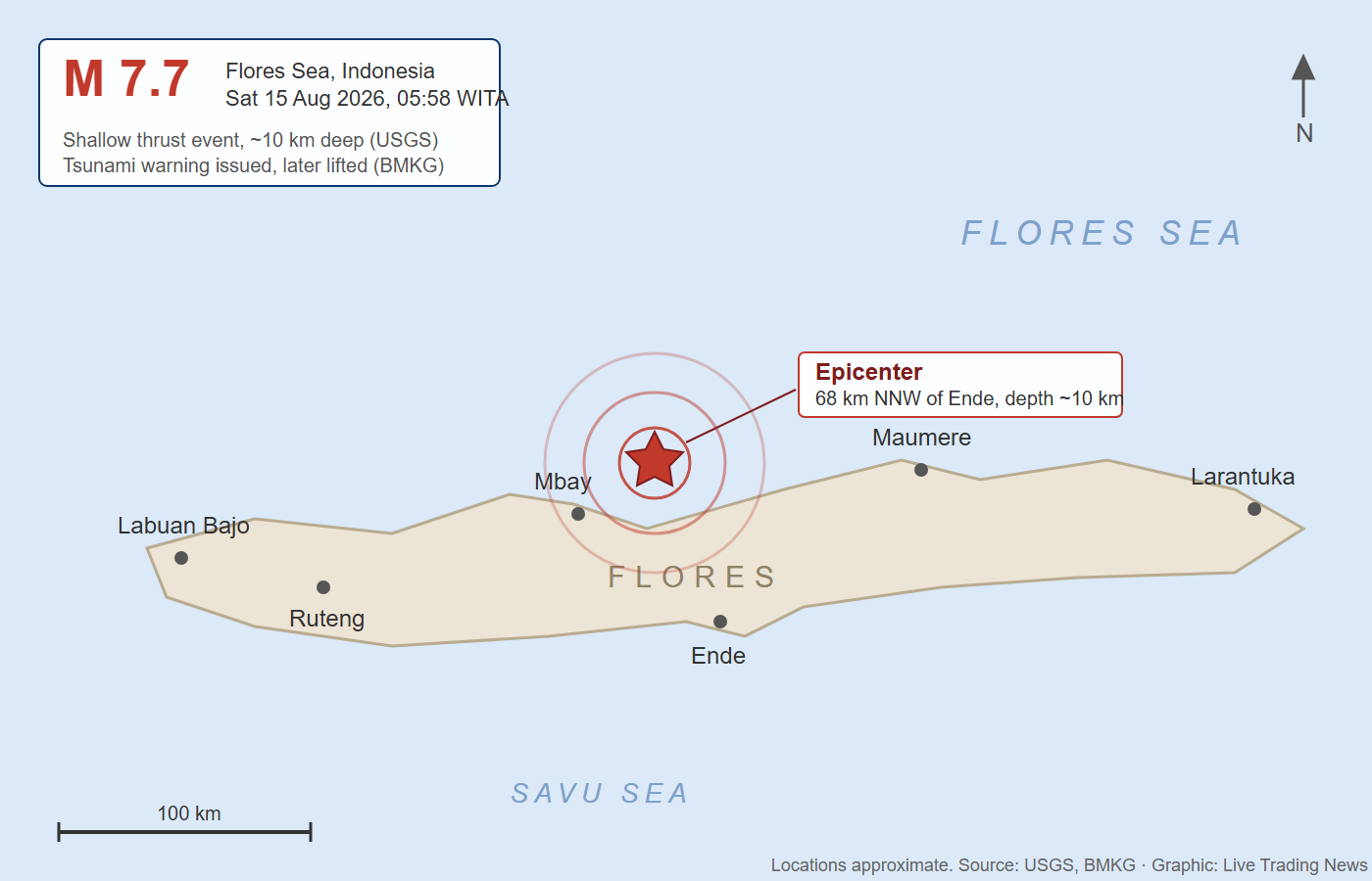
MAUMERE / FLORES, INDONESIA: A powerful magnitude 7.7 earthquake struck the Flores Sea off the northern coast of Flores Island in eastern Indonesia early Saturday, killing at least two people, damaging buildings, and prompting a rapid tsunami warning that sent thousands of residents fleeing to higher ground.
According to the United States Geological Survey (USGS) and Indonesia's Meteorology, Climatology, and Geophysical Agency (BMKG), the quake occurred at 5:58 a.m. local time (21:58 UTC on August 14). The epicenter was located approximately 68 kilometers (42 miles) north-northwest of the city of Ende in East Nusa Tenggara (NTT) province, or about 30–38 kilometers northeast of Mbay in Nagekeo Regency. The hypocenter was shallow, at a depth of roughly 10 kilometers according to the USGS (BMKG reported 10–15 km), a factor that intensified the shaking felt on land.
The tremor was felt strongly across Flores Island, including in Maumere (Sikka Regency), Ende, Nagekeo, and Ruteng, as well as in parts of West Nusa Tenggara and South Sulawesi. Residents described intense, prolonged shaking that lasted nearly a minute in some areas. Video circulating on social media showed people running through darkened streets in sleepwear, many carrying children, as power outages struck several districts.
Tsunami Warning Issued, Then Lifted
Given the magnitude and shallow depth, BMKG immediately issued a tsunami early warning covering coastal areas of East Nusa Tenggara, West Nusa Tenggara, South Sulawesi, and Southeast Sulawesi. Modeling indicated the potential for waves between 0.5 and 3 meters. Authorities urged residents along affected coastlines to move inland or to elevations higher than 10 meters and to stay away from beaches and riverbanks.
Coastal communities, particularly around Maumere and northern Flores, evacuated in the pre-dawn darkness. Some witnesses reported the sea receding, a classic precursor sign. However, after monitoring tide gauges and buoys for several hours, BMKG lifted the tsunami warning. Officials confirmed that minor tsunami waves had been recorded at multiple stations. The highest observed amplitude was approximately 0.94 meters at Maurole (Ende area). Other readings included about 0.36 m at Labuan Bajo, 0.19 m at Sikka, 0.38 m at Kewapante in the Sikka port area, 0.25 m at Flores Timur, 0.17 m at Dompu, and smaller anomalies elsewhere. No destructive, land-engulfing waves materialized.
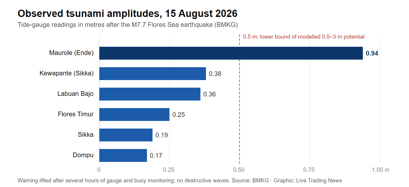
Tide-gauge readings stayed well below the modeled 0.5–3 meter potential, and the warning was lifted after several hours. Data: BMKG.
Casualties and Structural Damage
Indonesia's National Disaster Management Agency (BNPB) confirmed at least two fatalities, a man and a woman, at the El Say (L Say) port area in Maumere, Sikka Regency, with at least one additional person injured. Local media and AFP footage showed significant structural damage, including the partial collapse of a port terminal waiting room in Maumere. Homes and public buildings in Ruteng (Manggarai), Nagekeo, and other districts sustained cracks and heavier damage. Hospital patients in Ende were moved outdoors after walls cracked. Landslides were reported or anticipated in mountainous areas, potentially blocking roads and complicating early search-and-rescue access. Communication difficulties in remote coastal villages slowed full damage assessments.
Multiple aftershocks followed within the first hour, including events of magnitude 5.9, 5.6, and 6.1–6.2. BMKG recorded dozens of aftershocks in the subsequent hours. Authorities continue to warn of the risk of further strong aftershocks.
Seismic Context: The Ring of Fire and Historical Trauma
Indonesia's vast archipelago of more than 270 million people sits squarely on the Pacific "Ring of Fire," where the Indo-Australian plate converges with the Eurasian (Sunda) plate. The August 14–15 event involved reverse (thrust) faulting at shallow depth within this complex zone, roughly 350 km north of the Sunda Trench.
The trauma of past disasters remains vivid. On December 12, 1992, a magnitude 7.7–7.8 earthquake and subsequent local tsunami struck the same Flores region, killing an estimated 2,080 to 2,500 people, many in Maumere and on nearby Babi Island, and generating waves that reached as high as 26 meters in places. More recent events, including the 2004 Indian Ocean tsunami and the 2018 Sulawesi earthquake and tsunami, have reinforced a culture of rapid self-evacuation among coastal Indonesians.
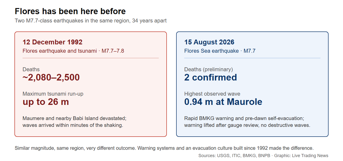
Two M7.7-class earthquakes in the same region, 34 years apart, with very different outcomes. Sources: USGS, ITIC, BMKG, BNPB.
Response and Outlook
As daylight returned over the Flores Sea, emergency responders, supported by national agencies and military personnel, moved into the hardest-hit areas to assess damage, treat the injured, and restore access. BNPB and local BPBD offices continue to compile casualty and damage figures. Residents have been advised to remain vigilant for aftershocks and to avoid damaged structures until they are inspected.
The USGS PAGER system assessed the event at Yellow alert level, estimating that approximately 1.2–1.5 million people experienced strong to severe shaking (MMI VI–VIII), with the potential for localized casualties and damage.
Sources & Citations
United States Geological Survey (USGS): M 7.7, 68 km NNW of Ende, Indonesia (2026-08-14 21:58:21 UTC; depth 10.0 km; reviewed).
BMKG (Badan Meteorologi, Klimatologi, dan Geofisika): official statements on magnitude, depth, the tsunami early warning, observed wave heights, and cancellation of the warning.
BNPB (Badan Nasional Penanggulangan Bencana): confirmed fatality and injury reports from the El Say / L Say port area in Maumere; evacuation guidance.
Al Jazeera, AFP, Reuters, The Jakarta Post, Channel News Asia, Tempo.co, and other contemporaneous reporting (August 15, 2026).
Historical context: the 1992 Flores earthquake and tsunami (USGS, ITIC, academic and archival records), magnitude ~7.7–7.8, ~2,500 fatalities.
This report has been fact-checked against primary agency data (USGS, BMKG, BNPB) and major international wire reporting available as of the morning of August 15, 2026. Casualty and damage figures remain preliminary and subject to revision as assessments continue.

ASEAN: The Next Great AI Superpower
AI is not software; it is infrastructure — power, land, water, fibre and chips. Shayne Heffernan on why Southeast Asia is emerging as the third pole of global AI, where the hyperscalers are building, and how to invest.
KDA Corporate Digital Currency Increases by Over 50% Since Listing on XT.com
Knightsbridge Group Positioned for Strong Asian Growth
China Free Trade Network Expanding
Every story, signed and delivered.
Subscribe to the kxco channel and get the headline, the AI-written key takeaways, and the chain-anchor link the moment we publish. Audio versions and per-ticker subscriptions arrive in the next iteration.